
ONE of Budleigh’s two main swimming areas is sandwiched between frequently polluting channels. The other area MAY be much cleaner. But contrary to explicit legislation, Budleigh’s water sampling reports on neither.
Petercrwilliams fightingpoolution.com
Beach water sampling is precisely regulated by the ‘2013 Bathing Water Directive’. This legislation clearly sets out the exact methodology that must be followed to provide a valid statement of the bathing water quality for all beaches.
One of the key instructions (not surprisingly), is how the sampling location must be selected at each beach. Here’s what the law says:

So it’s clear, the Environment Agency “must locate the point where most bathers are expected”.
So where on Budleigh beach do you think they sample?
- Maybe immediately below the Lime Kiln car park, where most Summer visitors park and head to the beach?
- Or alternatively, maybe Steamer Steps end – where most local swim, and is popular all year round?
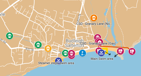
In fact, the EA sample a section of the beach where very few people swim! They sample the water quality just by our iconic telephone box, west of the Longboat Café.
So the key question: does this make a difference to people’s swimming safety – and would you change your behaviour if you knew the facts?
The key purpose of water sampling, analysis and forecasting is to provide information that we can act on. Is it a good place to swim generally, and is it good to swim today?
Sampling the Telephone box location provides little useful information for any water user at Lime Kiln or Steamer Steps.
To understand why, we need to take a look at the ‘Sewage Map of Budleigh’.
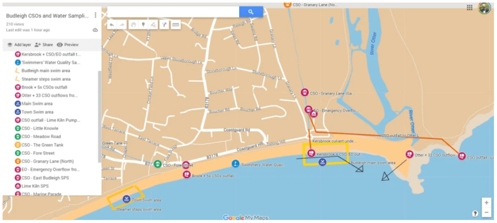
You can see the Blue Sampling location flag in the middle of the map – where the water is sampled.
You can also see all of the sewage overflow points and outfalls (colour coded from RED = highest polluting outlet, to Green = lower polluting). Prevailing currents are marked with the black arrows.
The Lime Kiln car park and swim area is just a few metres ‘downstream’ from the Kersbrook outfall, which enters the beach below the west end of the carpark. This carries any sewage discharged from two Combined Sewage Overflows (CSOs), plus an Emergency Overflow, straight into the sea.
- On 20th June 2023, the Environment Agency sampled the Kersbrook, just before it enters the sea, and found it contained greater than 100,000 E-coli cfu/100ml. That’s more than 200 times greater than the ‘safe’ limit for E-coli bacteria!
- On 3rd August 2023, the Environment Agency found it contained more than 40 times the ‘safe’ E-coli limit!
- On 4th July 2023, South West Water released raw sewage, sanitary towels and PPE into the Kersbrook through an Emergency Overflow, and from there directly into the sea. This discharge has been confirmed by the Environment Agency after an FOI request. Further details and photos of this can be found on the ‘Budleigh Sewage Action’ home page.
- The EA sampled this point 20 times in Summer 2023, and – on average – the samples contained E-coli concentrations more than 14 times greater than the ‘safe’ limit for bathing.
And here’s the Kersbrook outfall as it enters the beach – on the edge of the Lime Kiln bathing area.

“Bubble, bubble, toilet trouble?” Kersbrook outfall below Lime Kiln car park
Go to the original article to watch video.
It’s important to point out that any sewage quickly mixes and gets diluted when it enters the sea, but in the local vicinity of these outfalls (maybe a few hundred meres), concentrations can still be significantly elevated for some time after a discharge. That’s exactly why pollution forecasts are mandatory during the Summer season, but these are based on the impact at the telephone box location.
But that’s not all that swimmers at Lime Kiln have to contend with.
The prevailing current carries the Kersbrook outfall along the bathing beach towards the Otter Estuary.
However, the Otter Estuary itself brings water which receives 31 of South West Water’s sewage overflows (CSOs) and pumping stations during its journey from the Blackdown Hills, as well as significant agricultural run-off. The Environment Agency’s average E-coli reading from the mouth of the River Otter in 2023 was approx. 3,200 E-coli cfu/100ml, that’s a large volume of water at more than 6 times greater than the ‘safe’ E-coli limit for bathing. And all of this bacterial load flows along the Lime Kiln beach area, and then out parallel with the Otter Ledge. Again, this water does mix and dilute when it reaches the sea, but there remains a localised effect for some distance.
So the beach next to Lime Kiln is located directly between these two significant pollution carriers, the effects of which are unlikely to be reasonably picked up by the existing ‘upstream’ sampling point at the Telephone box.
The reality is that we don’t know what the pollution load is actually like below Lime Kiln, because – contrary to the legal framework – no sampling is carried out in this area.
The opposite however, may be true for the Steamer Steps section of the beach.
We know that the background pollution level of the sea around Budleigh is very low. It also appears that the tidal current tends to run predominantly Eastwards along the sea front, potentially taking any bacterial load from the Marine Terrace sewage overflows / Knowle Brook outfall away from Streamer Steps.
So it’s not obvious to see that significant bacterial pollution would affect the Steamer Steps area – which may be some comfort to the majority of locals who use that area for their daily swims, all year round.
The problem is that we don’t know this. We can only surmise. And for as long as the Environment Agency only sample in a place where few people swim, that will continue to be the case.
So what ACTION do we want?
- Firstly, we need the EA to start sampling at both Steamer Steps and Lime Kiln – beginning in the 2024 Summer Season, and publishing results throughout the season along with the current ‘Telephone box’ sample data. Once they have done this – and published a year or two’s data, we can get a proper understanding of where in Budleigh it is safest to swim
- It would also be helpful if the EA could specifically forecast pollution alerts for the two main swimming areas, so people can make an informed choice in real time, of where and when to swim
- Lastly, we all need South West Water to reduce or eliminate this frequent stream of pollution being dumped into Budleigh’s brooks, and into the whole Otter catchment.
- It would also be great to see a comprehensive focus on cleaning up the agricultural pollution and run-off, right along the Otter river system.
How to achieve this?
- Write to the EA and our MP, quoting ‘Schedule 4’, of the ‘2013 Bathing Water Regulations’, to request that the Environment Agency sample in accordance with regulations
- Continue to put pressure on South West Water clean up their act
- Support any initiatives which aim to improve the water quality of the whole Otter river system
If you’d like to explore the live and interactive ‘Budleigh Sewage Hotspots Map’, click the link.
You can use this map to locate and see all of South West Water’s worst polluting hotspots in Budleigh. Click on each location to see what it looks like (easiest on a PC), and how much pollution it has dumped onto our beach in 2022. We will update this map once we get 2023’s sewage data.
In terms of sampling and forecasting for both Steamer Steps and Lime Kiln swimming areas, the 2013 Directive allows for just our situation, and specifically states that ‘where more than one swimming area is popular, and they are some distance apart, then both locations may be sampled’. That’s just what we need for both local swimmers and our many visitors.
