
Some EDDC activity at Exmouth has prompted the following conversation today on the EDA facebook: https://www.facebook.com/eastdevonalliance?hc_location=timeline
Daily Archives: 18 Feb 2014
What price flood insurance for the now approved Longboat cafe?
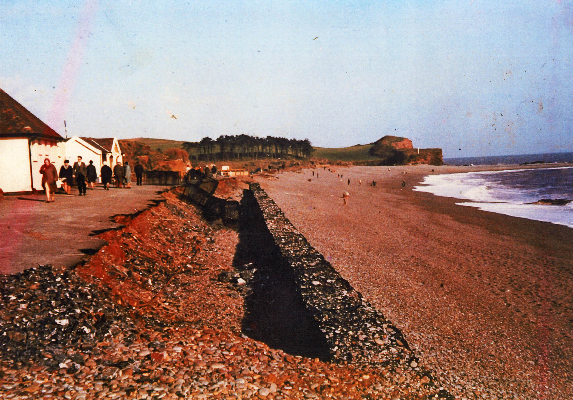
Some clues might be found in the following extract from a letter, dated 25 September 2009, to Mr John Wardle of the Devon Area Office of the Environment Agency. It was sent by Budleigh Salterton resident, David Daniel, and is headed ‘Data relevant to Flooding from the Sea – Budleigh Salterton’,and mentions that damage had occurred 7 times between 1970 & 2000.
‘Dear Mr Wardle
Thank you for letting me come over to meet you on Tuesday , to discuss flooding from the sea at Budleigh Salterton.
I have been collating the evidence of severely damaging storms and storm surges from records kept in the local Museum. These are mainly eyewitness accounts, newspaper cuttings and photographs. These are not a complete record of all storms only those of sufficient severity as to warrant special mention. From empirical evidence (which PPS25 seems to suggest should always be used where available), the part of the beach worst affected by storm driven flooding from the sea is the eastern section of approx 1.2 km, from the Longboat to the Otter Head, of the 4.5 km beach. I am of the opinion that the section of the beach subject to flood damage and the extent of this damage is not easily subject to predictive calculation. This is because it is a three dimensional hydrodynamic effect caused by wind, waves and the angle they hit the beach, but perhaps your experts can correct me.
From this I believe there were at least eight storms between 1951 and 2000 of sufficient severity to flood this section of the beach. Namely: mid 50’s; 1970 (Feb); 1974 (Jan or Feb); 1982; 1989 (16 Dec); 1990 (2 Feb); 1991(end March); and 2000 (Oct). (Approximately one every six years although in practice they are far from evenly spaced). The effects of global warming are predicted to increase the frequency and severity of these storm surges. This represents an annual flood risk of 16% which seems to me to be thirty times greater than the “high risk” threshold used as guidelines in PPS 25 for flooding from the sea. We seem to be in uncharted “exceptional risk” territory.
Budleigh Salterton beach is described as “naturally protected” by the pebbles washed out from the “Bunter Beds” and thrown onto an underlying sandy substructure. But this protection is dynamic. Living memory from my family relates that on occasion some severe storms scour the pebbles off the beach and then years later another storm will throw them back. This has meant in the past the temporary loss of paths and a threat to the protection of the Otter Estuary. So, following the 1970 storm, protective gabions were installed in 1972. Their height had to be increased in 1974. And they were extensively repaired again by EDDC in 1990 following the 1989 storm in which 150m of gabions were torn open directly in front of the Longboat House. These repairs were incomplete when further damage was sustained in February 1990.
The purpose of gabions is to contain erosion, although as you can see from the evidence, they are not invulnerable to the extraordinary power of the sea. They are not impervious and they do not stop water coming through them or over the top.
I enclose a selection of photographs to indicate the extent of erosion storms of this severity cause and strewn pebble “witness” of how high the water has carried them.
Yours sincerely,
David Daniel
Gabions installation, 1972

Storm 1974
Storm Dec 1989

The above letter will make uncomfortable reading for the owner of the Longboathouse cafe, as will reports in the national media of higher insurance premiums for properties, including small businesses, at risk of flooding.
The Inspector’s report and decision on the Longboathouse cafe appeal was announced today. Details here:
LB Appeal
Comments on the SIN blog at this link: http://sidmouthindependentnews.wordpress.com/2014/02/18/longboat-cafe-update/
EDDC planned relocation to Skypark…convenient for whom?
Is the ambitious office relocation to Skypark , a truly carbon-emissions-cutting move? See http://sidmouthindependentnews.wordpress.com/2014/02/18/carbon-tyre-prints/
Destination Skypark: the ‘underlying assumptions, and effects’, of EDDC’s planned move
Next week, EDDC councillors will be asked to vote for a £1,000,000 spend on land at Skypark, for new Council headquarters which could cost a whopping £15,000,000 of taxpayers’ money.
But can councillors make an informed decision on the scant evidence so far provided? No they can’t, according to the Overview and Scrutiny Committee (OSC), which voted by a two-thirds majority for further details to be released before any decision should be taken. Despite this serious caution from its own watchdog, the Cabinet seems intent on forging ahead, with councillors blindly in tow.
This has prompted Save Our Sidmouth (SOS) to send an appeal to all councillors to read the details and implications of the relocation plan, (in a document SOS has provided), before the vote at Full Council on Wednesday, 26th February (6.30 p.m at Knowle).
The SOS letter and document are here: http://saveoursidmouth.com/2014/02/18/sos-to-eddc-councillors-re-skypark/
